March 25, 2020
 Source/Unacast
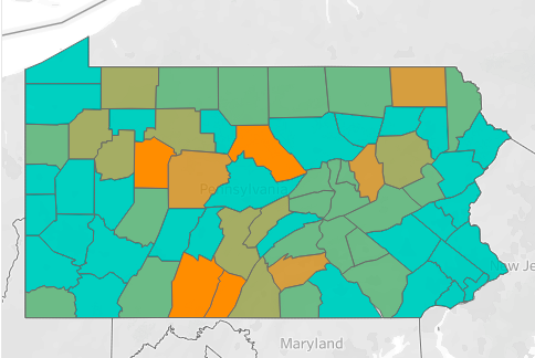
Philadelphia and the surrounding counties have received high grades for "social distancing" during the coronavirus pandemic, according to location data used to build an interactive map. Unacast, a startup, used smartphone GPS data to determine how the United States is responding to public health recommendations to prevent the spread of COVID-19.
Public health experts have spent weeks drilling the American public about the importance of practicing social distancing to slow down the spread of the coronavirus and maybe the message is beginning to be heard.
As the crisis in the United States continues to unfold, one start-up is using anonymous geolocation data to assign grades for social distancing in every county across the nation.
Unacast, an expert in "human mobility insights," typically collects location data to sell to businesses in retail, real estate, marketing and tourism. Their data comes from a variety of apps installed on our smartphones.
To gauge the impact of the COVID-19 pandemic in the United States, the company used its location tools to measure changes in the total distance traveled by people in each geographic unit. Big drops in total travel distance, in this case 40% or greater, indicate that social distancing has been adopted more broadly than in areas where distance traveled has remained closer to an average.
An interactive map based on Unacast's findings shows that Philadelphia, Montgomery, Bucks, Delaware and Chester counties have all received "A" grades for social distancing, so far.
The grades for the Philadelphia area reflect stay-at-home orders that have been handed down by Pennsylvania Gov. Tom Wolf and Philadelphia Mayor Jim Kenney, as well as the large number of businesses that have been shut down to prevent community spread of COVID-19.
Unacast acknowledges that the map, in its current form, only provides a rough idea of how much Americans are actually interacting with other people. The company plans to add layers to the map's functionality.
"We are in the process of understanding the best way to add layers that capture more of the complexity of social distancing: exploring how a change in the number of encounters for a given area, as well as a change in the number of locations visited, contribute to an area's social distancing score," Unacast said in a blog about its methodology.
States with the worst grades — Wyoming, Montana and Idaho — unsurprisingly have few confirmed cases of COVID-19 at this point in time. Other states with growing coronavirus totals still appear to be traveling greater distances than may be advisable under the circumstances.
Data collection companies are often viewed with suspicion for their abilities to tap into highly specific behavioral patterns of American citizens, potentially providing governments and private entities an entry to invade our privacy.
Already, geolocation policies in Israel and South Korea have prompted backlash from citizens who don't want to be tracked by their governments. Preserving civil liberties during a health crisis, particularly when geolocation data can be used to impact public safety, is proving to be a tightrope.
In the midst of a growing pandemic in the United States, epidemiologists and public health authorities may be able to use location data in the aggregate to analyze the spread of COVID-19. The U.S. government is reportedly already in talks with Google and other tech companies to use their geolocation resources to combat the coronavirus.
With information on how populations are responding to the crisis — and how the virus is responding to them — policymakers could have an invaluable tool in the critical months ahead.