October 04, 2016
As a roaring Hurricane Matthew tears roofs from homes in Haiti and heads north toward Cuba, it's looking at least probable that the storm will impact the Philadelphia region over the weekend.
The Category 4 storm – with 145-mph winds – has already killed seven people in the Caribbean and caused major damage. It was expected to drop 15 to 25 inches of rain in Haiti, and up to 40 inches in isolated places, along with up to 10 feet of storm surge and battering waves.
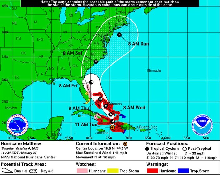
The latest potential track from the National Hurricane Center shows Matthew heading north on a general path along the east coast of Florida (Thursday into Friday morning), then up the Eastern Seaboard to the Jersey Coast (Sunday morning.)
National Weather Service forecasters said there is a high uncertainty regarding the track at this point.
"It is too early to say whether Matthew will curve out to sea or take a more northward track closer to the Mid-Atlantic coast later in the weekend," according to a Hazardous Weather Advisory.
A more northerly track would result in direct impacts, but even an offshore track will threaten potentially heavy rainfall in some locations during the weekend, warned forecasters, who encouraged people to keep up-to-date on the latest forecast.
Meanwhile, Matthew has left a mess of destroyed homes and thousands of people asking for help who cannot be evacuated now, officials said.
"They are getting everything a major hurricane can throw at them," said Dennis Feltgen, a meteorologist with the U.S. National Hurricane Center in Miami.
The latest advisory from the National Hurricane Center on Hurricane Matthew.
The storm was moving along the Windward Passage between Haiti and Jamaica, where it was dumping heavy rain that caused flooding. It was headed for southeastern Cuba and then into the Bahamas. The center of the storm was projected to pass about 50 miles northeast of the U.S. naval base at Guantanamo Bay, Cuba.
Forecasters said it could menace Florida toward the end of the week before possibly pushing its way up the East Coast over the weekend.
"We do not know yet whether the center of Matthew will actually come ashore in Florida. That's possible," said Rick Knabb, director of the hurricane center. "It also could go to the right and stay farther offshore. The farther offshore it is, the lesser the impacts will be, but the impacts are going to happen no matter what."
Florida Gov. Rick Scott urged residents along the state's Atlantic Coast to prepare for the possibility of a direct hit, and the Red Cross put out a call for volunteers in South Carolina.
Anxious Sunshine State residents raided grocery store shelves and North Carolina called for the evacuation of three barrier islands as Hurricane Matthew — the most powerful Atlantic storm in about a decade — threatened to rake a large swath of the East Coast in the coming days. A hurricane watch was in place for parts of Florida, which was already seeing rain bands from the storm.
Cameras outside the space station captured dramatic views of major Hurricane Matthew as the orbital complex flew 250 miles above (speed x4). pic.twitter.com/nfAQuw2OQC
— Intl. Space Station (@Space_Station) October 3, 2016
Simone Corrado and her husband tried to buy water at a Publix in their hometown of Davie, about 20 minutes from Miami Beach, and mostly found empty shelves. They were worried the roof of their garden-style apartment would leak during heavy rain.
"I got scared because all that was left at Publix was just the pricey water," Corrado said. "They really put the fear into you here. On the television screen every few minutes is the 'beep, beep, beep' storm alert."
As of 11 a.m., the storm was centered about 35 miles north-northeast of Tiburon, Haiti, and 90 miles south of the eastern tip of Cuba. It was moving north near 10 mph.
Meanwhile, a new storm has formed in the Atlantic. Tropical Storm Nicole – packing 50-mph winds – is 525 miles northeast of San Juan, Puerto Rico.
See the National Weather Service 7-day forecasts for Philadelphia and Ocean City below.
This Afternoon: Isolated showers. Mostly cloudy, with a high near 70. Northeast wind 9 to 14 mph. Chance of precipitation is 20 percent.
Tonight: Mostly cloudy, with a low around 53. Northeast wind 5 to 8 mph.
Wednesday: Mostly sunny, with a high near 71. North wind 6 to 8 mph.
Wednesday Night: Mostly clear, with a low around 54. East wind around 5 mph becoming calm in the evening.
Thursday: Sunny, with a high near 74. North wind around 5 mph.
Thursday Night: Mostly clear, with a low around 55.
Friday: Mostly sunny, with a high near 75.
Friday Night: Partly cloudy, with a low around 58.
Saturday: A chance of showers after 9 a.m. Mostly cloudy, with a high near 73. Chance of precipitation is 40 percent.
Saturday Night: A chance of showers. Mostly cloudy, with a low around 59. Chance of precipitation is 40 percent.
Sunday: A chance of showers. Mostly cloudy, with a high near 69. Chance of precipitation is 40 percent.
Sunday Night: Partly cloudy, with a low around 52.
Columbus Day: Sunny, with a high near 66.
This Afternoon: Isolated showers. Mostly cloudy, with a high near 68. Breezy, with a northeast wind 16 to 20 mph. Chance of precipitation is 20 percent.
Tonight: Mostly cloudy, with a low around 53. Northeast wind 14 to 16 mph.
Wednesday: Partly sunny, with a high near 68. Northeast wind 14 to 16 mph.
Wednesday Night: Partly cloudy, with a low around 56. Northeast wind 9 to 13 mph.
Thursday: Mostly sunny, with a high near 70. Northeast wind around 11 mph.
Thursday Night: Mostly clear, with a low around 58.
Friday: Mostly sunny, with a high near 73.
Friday Night: Mostly cloudy, with a low around 61.
Saturday: A chance of showers after 9 a.m. Mostly cloudy, with a high near 72. Chance of precipitation is 40 percent.
Saturday Night: A chance of showers. Mostly cloudy, with a low around 60. Chance of precipitation is 40 percent.
Sunday: A chance of showers. Mostly cloudy, with a high near 68. Breezy. Chance of precipitation is 40 percent.
Sunday Night: Partly cloudy, with a low around 53. Breezy.
Columbus Day: Sunny, with a high near 66. Breezy.
___
Associated Press writers Ben Fox and Jennifer Kay Miami contributed to this report.
 Source/National Hurricane Center/NWS