October 05, 2016
The National Weather Service in Mount Holly has canceled its hazardous weekend weather advisory for the Philadelphia region after weather models agreed Wednesday that Hurricane Matthew's track will take it out to sea and lessen any impact on this area.
Forecasters, however, warned people to stay current on the latest storm advisories.
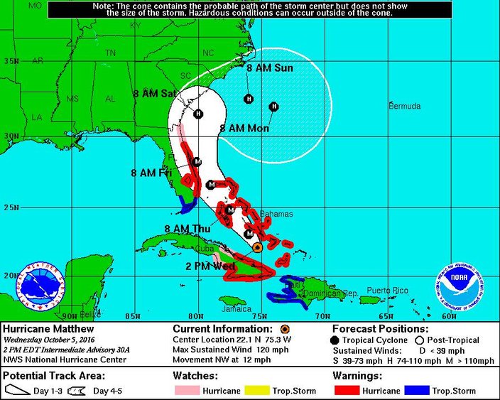
Various models came into alignment on the hurricane's track, now predicting it will slice up the eastern half of Florida, continue north to a position off the coast of North Carolina, and then meander for a bit before curving east later this week and heading out into the Atlantic Ocean.
Under that scenario, the storm's impact this weekend would be limited, including minor tidal flooding, sub-severe gusty winds and perhaps some moderate rain, especially near the Jersey Shore.
Forecasters said a cold front moving through on Saturday could briefly pull moisture from the hurricane northward ahead of it.
Meanwhile, preparations continue in Florida, as forecasters said the storm could hit the state – or come dangerously close — Thursday evening and then sideswipe the East Coast all the way up to the Carolinas over the weekend. Matthew could become the first major hurricane to blow ashore in the United States since Wilma slashed across Florida in 2005, killing five people.
At least a half-million people along the lower East Coast were urged to evacuate their homes.
 Source/National Hurricane Center/NWS
.
"If you're able to go early, leave now," Florida Gov. Rick Scott warned.
At least 11 deaths were blamed on the powerful storm during its weeklong march across the Caribbean, five of them in Haiti. But with a key bridge washed out, roads impassable and phone communications down, the western tip of Haiti was isolated and there was no full accounting of the dead and injured in Matthew's wake.
After moving past Haiti, Matthew rolled across a corner of Cuba and then began pounding the southern Bahamas with winds of 120 mph and heavy rain on a course expected to take it near the capital city of Nassau.
At 5 p.m. EDT Matthew was centered about 205 miles south-southeast of Nassau in the eastern Bahamas. It was heading northwest at 12 mph, according to the latest advisory from the National Hurricane Center in Miami. Hurricane-force winds extended outward up to 45 miles from the center, meaning Matthew could wreak havoc along the East Coast even if it did not actually come ashore.
Along the East Coast, people boarded up beach homes, some schools closed and residents began clearing out.
South Carolina Gov. Nikki Haley announced plans to evacuate a quarter-million people from the coast, not counting tourists, starting Wednesday afternoon. Florida's Broward County, which includes Fort Lauderdale, asked some 150,000 residents in low-lying areas or mobile homes to move to safety.
• • •
Here's the seven-day forecast for the Philadelphia region and the Jersey Shore:
Tonight: Increasing clouds, with a low around 55. Northeast wind 5 to 8 mph.
Thursday: Cloudy through mid morning, then gradual clearing, with a high near 74. North wind around 7 mph.
Thursday Night: Mostly clear, with a low around 54. Light east wind.
Friday: Mostly sunny, with a high near 75. Northeast wind 5 to 8 mph becoming east in the afternoon.
Friday Night: Isolated showers after 2 a.m. Mostly cloudy, with a low around 58. East wind around 6 mph. Chance of precipitation is 20 percent.
Saturday: Scattered showers, mainly after 8 a.m. Mostly cloudy, with a high near 70. Chance of precipitation is 50 percent. New precipitation amounts between a tenth and quarter of an inch possible.
Saturday Night: Scattered showers before midnight. Mostly cloudy, with a low around 54. Chance of precipitation is 30 percent.
Sunday: Mostly sunny, with a high near 66. Breezy.
Sunday Night: Mostly clear, with a low around 49.
Columbus Day: Sunny, with a high near 66.
Monday Night: Mostly clear, with a low around 49.
Tuesday: Mostly sunny, with a high near 67.
Tuesday Night: Partly cloudy, with a low around 52.
Wednesday: Mostly sunny, with a high near 69.